|

New Hope Creek From Chapel Hill Road to Chapel Hill-Durham Boulevard
(Component 2 of New Hope Corridor Open Space Master Plan)
Map · Photos · Description & Special Features · In the News · Master Plan Text
Related links:
A Survey of the Big Shellbark Hickory, White-nymph, and Other Species Associated with Rich Alluvial Forest Habitats in the New Hope Floodplain of Durham County by Stephen Hall and Carol Tingley, October 1, 2023
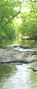
Photos
Click to enlarge.
    
Description and Special Features
Durham County has built a 2.2-mile natural surface loop trail—the New Hope Creek Bottomlands Trail—through beautiful bottomland hardwood forest between New Hope Creek and Sherwood Githens Middle School on the west side of the creek. Click here for a trail map.
In late summer 2010, the City of Durham will open Chapel Hill Road Park at this site. Click here for a PDF of the final site plan.
Please note that access to the New Hope Creek Bottomlands Trail is limited while the Park is being constructed. Access and parking from the Githens school playing field are no longer available. New permanent access will be available once the Park is completed. In the meantime, there is walking access via a neighborhood trail link that runs between the apartment complex on Watkins and the North Carolina Orthopedics Clinic on Southwest Durham Drive. The clinic has always been friendly about allowing parking for trail access as long as their business is not affected. Park back by the dumpster, and you will see an opening that leads to the sewer easement. Walk down, take a left, and the trailhead is just ahead on the right.
Have you hiked the New Hope Creek Trail?
Do you like giving back to your community?
Are you looking for volunteer service hours?
If you answered yes to any of these questions, you have what it takes to join the Durham County Community Conservation Program.
This might mean participating in a one-time trail workday or serving as a site steward for the trail. Site stewards are volunteers who walk the trail on a regular basis and note trail conditions.
For more information, email Jane Korest.
|
In the News
The Committee submitted comments on the Patterson Place development proposal, which would have affected Components 2, 4 and 5 of the New Hope Creek corridor. The proposal was rejected by the Durham Planning Commission on April 9, 2019. More information available on City of Durham website here.
Committee comments: Oct. 2018, Nov. 2018, Feb. 2019 and April 2019.
In January 2007, the NHCCAC passed a resolution urging Durham to relocate a planned soccer field that could negatively impact the creek. Text of the resolution and earlier information on development of the park are in the minutes of the January 11, 2007 meeting of the committee.
Routing of Light Rail Transit Corridor
The Durham-Chapel Hill-Carrboro Metropolitan Planning Organization (DCHC MPO) conducted a public hearing on the rail transit Alternatives Analysis at the January 11, 2012 meeting of its board, which is called the Transportation Advisory Committee (TAC).
The DCHC MPO approved the Locally Preferred Alternative for the Durham-Orange and Durham-Wake rail corridors in February 2012. For additional information, see the DCHC MPO Web page or contact Andy Henry, (919) 560-4366, x-36419, andrew.henry@durhamnc.gov.
The next steps for the projects are Scoping and PE/DEIS. Triangle Transit provided an overview of these steps at the last NHCCAC meeting. The following public workshops and meetings are scheduled:
- 5/2/2012: Regulatory Agency Meeting for Durham-Orange LRT, Extraordinary Ventures Center, Chapel Hill, 1-3 pm
- 5/2/2012: Public Scoping Meeting for Durham-Orange LRT, Extraordinary Ventures Center, Chapel Hill, 4-7 pm
- 5/3/2012: Elected Officials and Partners Meeting for Durham-Orange LRT, Durham Armory, 10 am-12 pm
- 5/3/2012: Public Scoping Meeting for Durham-Orange LRT, Durham Armory, 4-7 pm
These will determine the issues covered by their EIS, so it is very important that our comments on the "cross country" crossing of the corridor by LRT get on the agenda.
To follow the NHCCAC discussion of this issue, see the minutes of our April, June, July, August, September, November, and December 2011 minutes, and the January and February 2012 minutes, especially the resolution passed in August 2011. |
Text from 1991 New Hope Corridor Open Space Master Plan
Existing Land Use & Ownership
- Corps of Engineers lands along about half of the New Hope Creek length
- Sherwood Githens Middle School (Durham County Schools)
- Park land, Department of Parks and Recreation, City of Durham
- Residential tracts, medium- to low-density, private ownership
- Commercial and industrial uses to the east along Garrett Road
Future Land Use
Potential for development between New Hope Creek and Interstate 40 to the west is
very high. The Southwest Durham Plan (1989) shows Mixed Use near Interstate 40
and Office near New Hope Creek on the Chapel Hill-Durham Boulevard, and medium-
and high-density residential in the remainder of this area between New Hope Creek
and Interstate 40.
Significant Resources
This component is directly adjacent to the Corps of Engineers mitigation lands. Nine
vegetation sites have been identified in this component, comprising the Patterson Farm
Lowlands and Slopes. Steep slopes exist, mainly along the west
boundary of the floodplain.
Recommendations for Protection & Use
- Protect the entire 100-year floodplain north of the Corps land (130 acres).
- Protect the 200' steep slope buffer west of the floodplain.
- Provide trail access from Sherwood Githens Middle School to the future City
park site and to areas of botanical interest along the floodplain and on the steep
slopes.
- Establish a trail from Chapel Hill-Durham Boulevard to Chapel Hill Road along
the west side of the floodplain. The Durham Urban Trails and Greenways
Commission has recommended a greenway link in this area. Connection to
trails north of the Boulevard is possible underneath the Boulevard at the bridge.
- Incorporate plans for an open space connector into development plans for the
large tracts of land to the west (when they are developed). The connector would
follow the unnamed drainageway that flows across Watkins Road, then toward
New Hope Creek and Sherwood Githens Middle School.
- As the area south of Chapel Hill-Durham Boulevard develops, maintain a
vegetated buffer of at least 50 feet along the Boulevard's edges and incorporate
a bicycle/pedestrian trail leading westward toward Chapel Hill.
| |
| | |
|
| | | |
|