|

Sandy Creek from New Hope Creek to Duke University
(Component 3 of New Hope Corridor Open Space Master Plan)
Map · Photos · Description & Special Features · In the News · Master Plan Text
Oppose Development Proposal Near Sandy Creek!
Ascension Developers of Baltimore and Washington have submitted a proposal to rezone the lots on Pickett from the intersection of Ridge Rd to Sandy Creek Environmental Park and wetlands to build 140-150 apartments with 145 parking spaces. The Durham Zoning Commission rejected the proposal 8-2, but it now nevertheless proceeds to the Durham City Council for a vote.
Speak out to protect Sandy Creek and the New Hope Creek corridor. Call or write the City Council or speak out in person or by Zoom at the meeting on February 3 at 7pm.
The main opposition to this project is outlined below.
1) Environmental Impact:
The development would create a tremendous amount of runoff that would pollute our groundwater and drinking water. The construction and new impervious surfaces would send polluted runoff water via the downhill slopes straight to Sandy Creek, which runs into New Hope Creek, which then runs to the Jordan Lake Reservoir.
Sandy Creek Environmental Park supports wildlife and vegetation. It is a rare and very important urban wetlands area that we need to preserve. Impermeable developed land uphill from Sandy Creek would promote even more flooding in an already flood-prone area. Pollution and higher flood levels could destroy this important environmental area.
Sandy Creek Environmental Park serves as a flyway for migrating birds. The development's large 4-story glass building would create tremendous light pollution pouring over Sandy Creek, which is normally dark. Light pollution disrupts migration with confusion and deadly bird strikes as well as disrupting and hurting year-round birds and wildlife.
2) Traffic Danger and Increased Traffic
The blind hill with no shoulders is already dangerous. Adding a large development here would increase that danger.
The 208 Vintage Durham apartment complex of about 4-5 buildings down the street is still being completed. Only the first building has been completed; the remaining buildings will not be completed until April. Therefore, the traffic study conducted by Ascension is invalid until those are built and at least 75% occupied.
3) Poor Location for More Apartments
There is only a 50% occupancy rate in the apartment complexes within a one-mile radius on Garrett Rd, Western By-pass and Tower Blvd, including the partly constructed Vintage Durham and 900 apartments being built on 15-501 between Garrett Rd and Mt Moriah/New Hope Commons (the latter, sadly, just upland and adjacent to New Hope Creek).
The parking allotted, 145 spaces for 140-150 apartments is inadequate in itself (and we certainly don't want more!) but there is zero extra parking in the area, producing another potential danger.
We are not necessarily opposed to some development at this location but it should be done on a much smaller scale and kept environmentally friendly for Sandy Creek. Read our letter to the Planning Commission.
To learn more, visit pickettroadzoning.com. |
Photos
Click to enlarge.
  
Description and Special Features
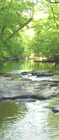
This component of New Hope Creek features the lovely Sandy Creek Park, which hosts the annual Bird & Butterfly Festival during Durham Creek Week in March. Visit Friends of Sandy Creek for the latest photos and updates on events at the park, or to make a tax-deductible, online donation to Sandy Creek construction and programs.
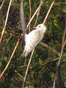
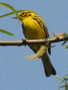
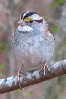
A 0.7-mile biking and walking trail runs along Sandy Creek from Pickett Road to Sandy Creek Park at the end of Sandy Creek Road (parallel to 15/501). The trail and surrounding wetlands are teeming with wildlife. Geese, ducks, herons, hawks, bluebirds, owls, woodpeckers, deer, beavers, turtles, and water snakes have all been spotted along this short trail. A wildlife observation platform has been erected overlooking a pond.
To see where the park is located, look for the solid purple line on the Sandy Creek map.
On Saturday, March 19, 2011, we held our first Bird and Butterfly Festival and Sandy Creek cleanup as part of Durham Creek Week. The second annual festival was held on March 17 and 24, 2012 and the third on March 23, 2013. Click here to read more and see photos from past festivals.
On October 6, 2012, we held a fall celebration at Sandy Creek Park
including a ceremony to officially name the new bridge in memory of New Hope Creek preservation pioneer Ken Coulter, a noted landscape architect who wrote the New Hope Creek Corridor Plan and the plan for Sandy Creek Park. Read the resolution regarding the bridge-naming.
In November 2010, Sandy Creek Park was named a birding "hotspot" by eBird.org. Click here for more information and here for a list of bird species that have been seen in Sandy Creek Park. The website of the Carolina Bird Club also has a page on the Sandy Creek Trail. Nate Swick, creator of the blog The Drinking Bird, writes about a trip to Sandy Creek Park in a post titled The other side of birding with baby.
Jeffrey Pippen has provided information for those looking for butterflies at Sandy Creek Park.
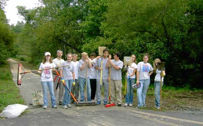
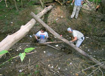
The trail has been adopted by the Durham Academy. Students and teachers at the Academy hold regular work days on the trail. Here are photos of some of the trail workers.
In the News
Links to news stories about Sandy Creek:
Text from 1991 New Hope Corridor Open Space Master Plan
Existing Land Use & Ownership
- South of Chapel Hill-Durham Boulevard: privately owned multifamily units and commercial establishments
- North of Chapel Hill-Durham Boulevard: privately owned single-family and multifamily residences; land owned by the City of Durham (former sewer plant), Cresset Academy, Durham Academy
- East of US 15-501 bypass and north of Cornwallis: Duke University (golf course, West Campus)
Future Land Use
The corridor along Sandy Creek, much like Mud Creek, appears to be developed to about its maximum potential,
given existing land use controls. The largest pieces of open space land exist at the former city sewer
plant site, the Duke University golf course, and the large parcel of city-owned land between the
abandoned sewer plant and Garrett Road.
Significant Resources
Sandy Creek is a small urban stream, arising in the Duke University campus area, flowing along the Duke golf course. On the west side of the US 15-501 bypass, it passes through several residential areas and beside two school properties. Just north of Chapel Hill-Durham Boulevard is an abandoned city-owned former sewage treatment plant. The former treatment plant offers the opportunity for developing a major city park, which is needed in this area of the city. This park can provide
both active recreation and trails linking schools, residential areas, a shopping center, and the main New Hope Creek trail. An existing nature trail along an abandoned sewer line is another attractive feature.
It is from the urban character of this stream that its best use is determined. Besides preserving the floodplain in natural vegetation, this is an ideal location for a trail serving for both recreation and alternative transportation. Together, the Mud Creek corridor (component 7) and the
Sandy Creek corridor provide the opportunity for a loop trail. Sandy Creek is indicated as a greenway trail on the Durham Urban Trails and Greenways (DOST) Master Plan.
Recommendations for Protection & Use
- Establish a bike and pedestrian trail from New Hope Creek to the vicinity of Duke Univeristy West Campus. This trail should begin just north of Chapel Hill-Durham Boulevard, follow an easement along the boulevard property line of Oak Creek Village shopping center and across Garrett Road. It would proceed eastward along the service road to Sandy Creek, then across the city-owned land, which should be designated as open space and recreational land. (An alternative route for the trail would be from Mud Creek through Garrett Farms, across Garrett Road by Cresset School to city-owned land on Sandy Creek.) The trail then should proceed north across Pickett Road, behind the residential areas of Colony Hill and Colony Park, and then to Cornwallis Road. Between the US 15-501 bypass and the golf course, the trail could either follow the edge of the highway right-of-way or link into a pathway that has been established beside the golf course. At NC 751, the trail would arrive at the entrance to Duke University described under component 9.
- Protect the entire 100-year floodplain.
- Improve the existing nature trail east of the main trail.
| |
| | |
|
| | |