|

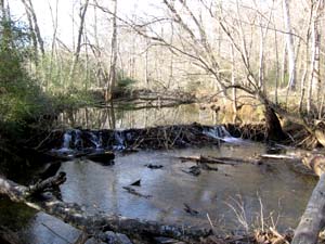
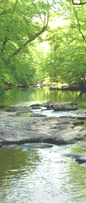
New Hope Creek From Chapel Hill-Durham Boulevard to Erwin Road(Component 4 of New Hope Corridor Open Space Master Plan)Related links:A Survey of the Big Shellbark Hickory, White-nymph, and Other Species Associated with Rich Alluvial Forest Habitats in the New Hope Floodplain of Durham County by Stephen Hall and Carol Tingley, October 1, 2023 PhotosClick to enlarge. Description and Special FeaturesSomeday soon, this stretch of the New Hope will be home to the New Hope Creek Preserve (see the Hollow Rock page for more details). This section is subject to intense development pressures, particularly along US 15-501. Our committee keeps a close watch on developments in this area, including construction of the New Hope Commons shopping center some years ago. We are currently monitoring the Indigo Corners complex that is being built on the northeast corner of 15-501 and Mt. Moriah Road directly abutting the creek. Component 4 of the Master Plan also encompasses the Trinity School on Pickett Road. Trinity School owns the Dallas D. Branch, Sr. Nature Preserve, which includes a trail along the creek. The land for the preserve was donated to the school by the Branch family in 1999. In January 2007, Trinity School sold 26.5 acres of land along New Hope Creek to Orange County for future preservation (read more about this sale). In the NewsThe Committee submitted comments on the Patterson Place development proposal, which would have affected Components 2, 4 and 5 of the New Hope Creek corridor. The proposal was rejected by the Durham Planning Commission on April 9, 2019. More information available on City of Durham website here. Committee comments: Oct. 2018, Nov. 2018, Feb. 2019, April 2019 and May 2019. Links to news stories about Component 4:
Text from 1991 New Hope Corridor Open Space Master PlanExisting Land Use & Ownership
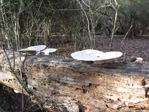
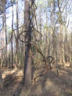
Future Land Use The potential for development along Chapel Hill-Durham Boulevard is extremely high. Rezoning on the north side was proposed in 1990 and later withdrawn. A proposed grade-separated interchange in the vicinity of Mt. Moriah Road would have an extremely high impact on the ridge uplands and north-facing slopes. Lands along both Mt. Moriah and Cambridge Roads, because of their proximity to the Interstate 40/US 15-501 interchange, appear to be very valuable as developable land. Zoning is as follows: in Durham, R-20 single-family residential (1 dwelling unit per 1/2 acre), and commercial along Chapel Hill-Durham Boulevard; in Chapel Hill, rural transition (1 dwelling unit per 2.3 acres); and in Orange County, rural buffer (1 dwelling unit per 2 acres). Proposed Connector Road: The regional Thoroughfare Plan includes a proposal for a connecting road that would permit traffic originating in the Chatham County and Chapel Hill vicinity to access Durham and US 15-501 more efficiently. Significant Resources This component of the corridor is perhaps the hub of hydrological and biological systems occurring in the entire area. It is at this location that the Mud Creek, New Hope Creek, and Dry Creek floodplains meet. It is the furthest point upstream where the New Hope Creek flows into its wide Triassic Basin floodplain. Nineteen vegetation sites have been identified in this section, comprising the following groupings: New Hope Creek-Dry Creek-Mud Creek Lowlands; Boulevard Ridge Uplands; and Garrett Farm Peninsula Uplands (see Appendix E of Master Plan). Unlike the Corps lands to the south, this area bears the marks of recent agricultural practices—open meadows, old farm roads, plowed fields, and managed woodlots. Preservation would include continuing these land uses as interpretive activity. The Boulevard Ridge Uplands includes sites on steep north-facing slopes. The Garrett Farms Peninsula Uplands sites, which were originally identified in the Harrison report, have been significantly compromised by the building of the Garrett Farms subdivision. Component 4 includes several units determined by environmental considerations and potential land development. The portion of the 100-year floodplain from Erwin Road southward to Garrett Farms retains a greater degree of environmental integrity than do the portions closer to the Boulevard and on the lower reach of Mud Creek. This is due to the fact that adjacent land has not yet been developed as intensely. Also, sewer lines have not been extended northwest of Garrett Farms. This lower degree of disturbance on the adjacent uplands offers a continued potential for wildlife habitat preservation no longer possible south of Garrett Farms. Protection measures must be introduced before the adjacent lands undergo intense development. Recommendations for Protection & Use
* Text in parentheses added as an amendment by the Durham Board of County Commissioners. |